
Make a donation
Gear up for your next adventure:
As an Amazon Associate, this site earns from qualifying purchases at no extra cost to you.
Einbeck topographic map
Click on the map to display elevation.
Make a donation
Gear up for your next adventure:
As an Amazon Associate, this site earns from qualifying purchases at no extra cost to you.
Einbeck
In the Early Middle Ages a number of villages existed along the river Ilme in the middle Leine valley before Einbeck was founded. On January 1, 1158 Einbeck was first mentioned in a deed of Friedrich Barbarossa, which mentioned … in loco qui Einbike vocatur …. and related to a transfer of an estate in the 11th century. Count Udo of Katlenburg owned an estate on the bank of a brook, the Krummes Wasser (crooked water). His grandson founded the stift Sankt Alexandri, that subsequently developed into an important sanctuary. On the other side of this brook a market town developed at the end of the 12th century, mainly due to convenient access for traffic. A church was built there as well, the market church (St. Jacob). The floodplain between market and stift was filled in and covered with buildings. The market and stift were walled in and a moat was built. In 1252 Einbeck received a town charter and a town council was established. In 1279 the town received through its sovereign, Heinrich Mirabilis, an extension of its town charter. Einbeck was topographically extended and a town wall is mentioned that enclosed the market church St. Jacob and the stift St. Alexandri. St Jacob was (and is) located in the center of the city around the 'old market', St. Alexandri was built only some hundred meters away. Extensions were called the 'new market', first mentioned 1389 as was the 'new town'. The new town received its own church, St. Mary, first mentioned 1318.
Make a donation
Gear up for your next adventure:
As an Amazon Associate, this site earns from qualifying purchases at no extra cost to you.
About this map
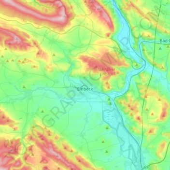
Name: Einbeck topographic map, elevation, terrain.
Location: Einbeck, Landkreis Northeim, Lower Saxony, 37574, Germany (51.73063 9.75857 51.91387 10.04135)
Average elevation: 198 m
Minimum elevation: 95 m
Maximum elevation: 425 m
Make a donation
Gear up for your next adventure:
As an Amazon Associate, this site earns from qualifying purchases at no extra cost to you.
Other topographic maps
Click on a map to view its topography, its elevation and its terrain.
Make a donation
Gear up for your next adventure:
As an Amazon Associate, this site earns from qualifying purchases at no extra cost to you.