
Thank you for supporting this site ❤️
Make a donation
Make a donation
Gear up for your next adventure:
As an Amazon Associate, this site earns from qualifying purchases at no extra cost to you.
Fussingen topographic map
Click on the map to display elevation.
Thank you for supporting this site ❤️
Make a donation
Make a donation
Gear up for your next adventure:
As an Amazon Associate, this site earns from qualifying purchases at no extra cost to you.
Fussingen
Die Jahresmitteltemperatur liegt bei 7,2 °C. Die mittlere jährliche Niederschlagsmenge beträgt etwa 760 Millimeter und ist damit etwas geringer als im Oberwesterwald, aber deutlich höher als im Limburger Becken.
Thank you for supporting this site ❤️
Make a donation
Make a donation
Gear up for your next adventure:
As an Amazon Associate, this site earns from qualifying purchases at no extra cost to you.
About this map
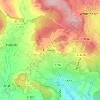
Name: Fussingen topographic map, elevation, terrain.
Average elevation: 325 m
Minimum elevation: 227 m
Maximum elevation: 429 m
Thank you for supporting this site ❤️
Make a donation
Make a donation
Gear up for your next adventure:
As an Amazon Associate, this site earns from qualifying purchases at no extra cost to you.