
Nantwich topographic map
Interactive map
Click on the map to display elevation.
About this map
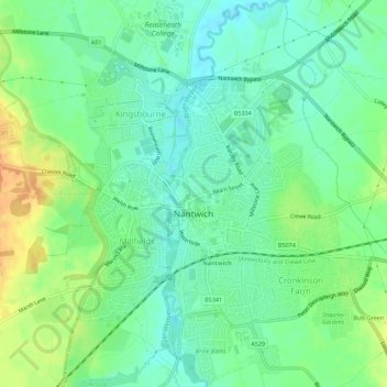
Name: Nantwich topographic map, elevation, terrain.
Location: Nantwich, Cheshire East, Angleterre, Royaume-Uni (53.05221 -2.54047 53.08552 -2.49598)
Average elevation: 45 m
Minimum elevation: 31 m
Maximum elevation: 66 m
Other topographic maps
Click on a map to view its topography, its elevation and its terrain.
Cotton Relief 1
Royaume-Uni > Angleterre > Cheshire East
Cotton Relief 1, Millington and Rostherne, Cheshire East, Angleterre, Royaume-Uni
Average elevation: 50 m
Middlewich
Royaume-Uni > Angleterre > Cheshire East
Middlewich, Cheshire East, Angleterre, Royaume-Uni
Average elevation: 40 m
Cranage
Royaume-Uni > Angleterre > Cheshire East
Cranage, Cheshire East, Angleterre, Royaume-Uni
Average elevation: 52 m