
Make a donation
Gear up for your next adventure:
As an Amazon Associate, this site earns from qualifying purchases at no extra cost to you.
Lewisville topographic map
Click on the map to display elevation.
Make a donation
Gear up for your next adventure:
As an Amazon Associate, this site earns from qualifying purchases at no extra cost to you.
Lewisville
Lewisville is at 33°2′18″N 97°0′22″W / 33.03833°N 97.00611°W / 33.03833; -97.00611 (33.038316, −97.006232) at an elevation of about 550 feet (170 m). It has a total area of 42.47 square miles (110.0 km2), of which 36.4 sq mi (94 km2) is land. It lies at the southern end of Denton County and the northern end of the Dallas–Fort Worth metroplex, in the eastern part of the Cross Timbers region of Texas between the Texas Blackland Prairies and the Grand Prairie. Vista Ridge, a small plateau, is in the southeast corner of Lewisville, and the lowest part of Denton County, at 484 feet (148 m), is found in the city. Lewisville sits above the Barnett Shale, a geological formation containing a large quantity of natural shale gas.
Make a donation
Gear up for your next adventure:
As an Amazon Associate, this site earns from qualifying purchases at no extra cost to you.
About this map
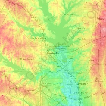
Name: Lewisville topographic map, elevation, terrain.
Location: Lewisville, Denton County, Texas, 75067, United States (32.88623 -97.15417 33.20623 -96.83417)
Average elevation: 174 m
Minimum elevation: 125 m
Maximum elevation: 242 m
Make a donation
Gear up for your next adventure:
As an Amazon Associate, this site earns from qualifying purchases at no extra cost to you.