Geolocate

Aloha topographic map

Click on the map to display elevation.

About this map

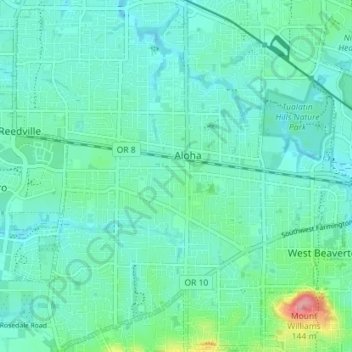
Name: Aloha topographic map, elevation, terrain.

Location: Aloha, Washington County, Oregon, United States (45.46643 -122.90512 45.51629 -122.84113)

Average elevation: 66 m

Minimum elevation: 46 m

Maximum elevation: 153 m

Other topographic maps

Click on a map to view its topography, its elevation and its terrain.

Gales Creek

United States > Oregon > Washington County

Average elevation: 128 m

Buxton

United States > Oregon > Washington County

Average elevation: 146 m

Gear up for your next adventure:

🧤Rechargeable Heated Gloves - Extreme warmth for Canadian winter expeditions
🔪Outdoor Multitool - Versatile tool for repairs and food prep in the wild
🎒Hiking Daypack - Lightweight and durable backpacks for day trips and excursions
🧦Hiking Liner Socks - Thin base layer to prevent friction and blisters
Camping Coffee Maker - Brew fresh coffee anywhere on the topographic map

As an Amazon Associate, this site earns from qualifying purchases at no extra cost to you.