
Make a donation
Gear up for your next adventure:
As an Amazon Associate, this site earns from qualifying purchases at no extra cost to you.
Pine Bluffs topographic map
Click on the map to display elevation.
Make a donation
Gear up for your next adventure:
As an Amazon Associate, this site earns from qualifying purchases at no extra cost to you.
About this map
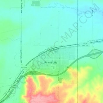
Name: Pine Bluffs topographic map, elevation, terrain.
Location: Pine Bluffs, Laramie County, Wyoming, 82082, United States (41.16429 -104.08184 41.20337 -104.05333)
Average elevation: 1,549 m
Minimum elevation: 1,519 m
Maximum elevation: 1,627 m
Make a donation
Gear up for your next adventure:
As an Amazon Associate, this site earns from qualifying purchases at no extra cost to you.
Other topographic maps
Click on a map to view its topography, its elevation and its terrain.
Curt Gowdy State Park
United States > Wyoming > Laramie County
Park terrain consists of rolling hills and sharp granite outcroppings in the foothills of the Laramie Mountains. Elevation ranges from 6,450 feet (1,970 m) to over 7,500 feet (2,290 m). Wildlife that can be found include: kokanee salmon, perch, brown, rainbow and lake trout, white-tailed deer, and mule deer.…
Average elevation: 2,271 m
Make a donation
Gear up for your next adventure:
As an Amazon Associate, this site earns from qualifying purchases at no extra cost to you.