
Make a donation
Gear up for your next adventure:
As an Amazon Associate, this site earns from qualifying purchases at no extra cost to you.
Cobija topographic map
Click on the map to display elevation.
Make a donation
Gear up for your next adventure:
As an Amazon Associate, this site earns from qualifying purchases at no extra cost to you.
Cobija
Cuenta con una población de unos 65 000 habitantes, y está situada a orillas del río Acre, frontera con el estado brasileño de Acre, a una altitud de 228 msnm. Tiene un clima tropical y lluvioso. Es la capital departamental menos poblada del país.
Make a donation
Gear up for your next adventure:
As an Amazon Associate, this site earns from qualifying purchases at no extra cost to you.
About this map
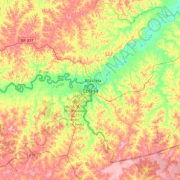
Name: Cobija topographic map, elevation, terrain.
Average elevation: 236 m
Minimum elevation: 172 m
Maximum elevation: 297 m
Make a donation
Gear up for your next adventure:
As an Amazon Associate, this site earns from qualifying purchases at no extra cost to you.