
Sunshine topographic map
Interactive map
Click on the map to display elevation.
About this map
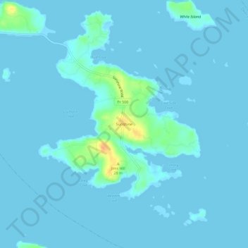
Name: Sunshine topographic map, elevation, terrain.
Location: Sunshine, Deer Isle, Hancock County, Maine, United States (44.17730 -68.60113 44.21730 -68.56113)
Average elevation: 3 m
Minimum elevation: -2 m
Maximum elevation: 38 m
Other topographic maps
Click on a map to view its topography, its elevation and its terrain.
Sunset
United States > Maine > Hancock County > Deer Isle
Sunset, Deer Isle, Hancock County, Maine, 04683, United States
Average elevation: 14 m
Flat Island
United States > Maine > Hancock County > Deer Isle
Flat Island, Deer Isle, Hancock County, Maine, United States
Average elevation: 8 m