
Make a donation
Gear up for your next adventure:
As an Amazon Associate, this site earns from qualifying purchases at no extra cost to you.
North Berwick topographic map
Click on the map to display elevation.
Make a donation
Gear up for your next adventure:
As an Amazon Associate, this site earns from qualifying purchases at no extra cost to you.
North Berwick
According to the United States Census Bureau, the town has a total area of 38.16 square miles (98.83 km2), of which, 38.02 square miles (98.47 km2) of it is land and 0.14 square miles (0.36 km2) is water. North Berwick is drained by the Great Works River and its tributary, the Negutaquet River. Bauneg Beg Hill, elevation 866 feet (264 m) above sea level, is the town's highest point.
Make a donation
Gear up for your next adventure:
As an Amazon Associate, this site earns from qualifying purchases at no extra cost to you.
About this map
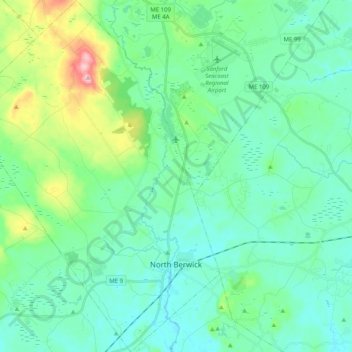
Name: North Berwick topographic map, elevation, terrain.
Location: North Berwick, York County, Maine, 03906, United States (43.26976 -70.85723 43.41668 -70.70928)
Average elevation: 75 m
Minimum elevation: 29 m
Maximum elevation: 257 m
Make a donation
Gear up for your next adventure:
As an Amazon Associate, this site earns from qualifying purchases at no extra cost to you.
Other topographic maps
Click on a map to view its topography, its elevation and its terrain.