
Make a donation
Gear up for your next adventure:
As an Amazon Associate, this site earns from qualifying purchases at no extra cost to you.
Annot topographic map
Click on the map to display elevation.
Make a donation
Gear up for your next adventure:
As an Amazon Associate, this site earns from qualifying purchases at no extra cost to you.
Annot
The village is located within a resurgence of sandstone amidst limestone mountains at 680 m altitude. This resurgence is up to 250m thick. The rocky ridge overlooking the village is formed of sandstone. The debris that has formed below in picturesque shapes with names such as: the Dent du Diable (Tooth of the Devil), the Chambre du Roi (King's Chamber), the défilé des Garambes (Defile of Garambes), the Chameau des lumières (Camelback of lights), and the rocks of the Cent-Marches (Hundred Steps). It has been classed as a natural site since 1920. Certain houses have been built directly against a rock fallen from the crag: the rock is bigger than a house. The acidic soils on the left bank of the Vaïre allow for chestnut growing.
Make a donation
Gear up for your next adventure:
As an Amazon Associate, this site earns from qualifying purchases at no extra cost to you.
About this map
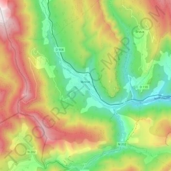
Name: Annot topographic map, elevation, terrain.
Average elevation: 1,063 m
Minimum elevation: 581 m
Maximum elevation: 1,704 m
Make a donation
Gear up for your next adventure:
As an Amazon Associate, this site earns from qualifying purchases at no extra cost to you.
Other topographic maps
Click on a map to view its topography, its elevation and its terrain.
La Gravette
France > Provence-Alpes-Côte d'Azur > Alpes-de-Haute-Provence > Barcelonnette
Average elevation: 1,282 m
Chaumie Bas
France > Provence-Alpes-Côte d'Azur > Alpes-de-Haute-Provence > Chaumie
Average elevation: 1,677 m
Digne-les-Bains
France > Provence-Alpes-Côte d'Azur > Alpes-de-Haute-Provence > Digne-les-Bains > Digne-les-Bains
Average elevation: 791 m
Make a donation
Gear up for your next adventure:
As an Amazon Associate, this site earns from qualifying purchases at no extra cost to you.
Saint-Ours
France > Provence-Alpes-Côte d'Azur > Alpes-de-Haute-Provence > Val-d'Oronaye > Saint-Ours
Average elevation: 2,031 m
Ouvrage de Haut-Saint-Ours
France > Provence-Alpes-Côte d'Azur > Alpes-de-Haute-Provence > Val-d'Oronaye > Saint-Ours
Average elevation: 1,929 m
Fouillouse
France > Provence-Alpes-Côte d'Azur > Alpes-de-Haute-Provence > Saint-Paul-sur-Ubaye
Average elevation: 2,103 m