Geolocate

Ragja topographic map

Click on the map to display elevation.

About this map

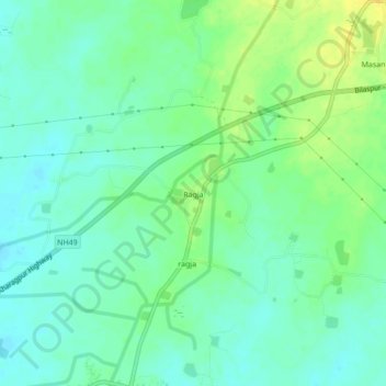
Name: Ragja topographic map, elevation, terrain.

Location: Ragja, Sakti Tahsil, Sakti, Chhattisgarh, 495689, India (22.03198 82.96333 22.07198 83.00333)

Average elevation: 244 m

Minimum elevation: 235 m

Maximum elevation: 259 m

Gear up for your next adventure:

🛶Canoe Life Vest - Safety vest for water sports
🥾Mountain Hiking Boots - High-traction boots for rocky terrain
🔦LED Headlamp - Hands-free lighting for early morning starts or late finishes
🌬️Windproof Camp Stove - Efficient cooking even on exposed mountain peaks
🧰Emergency Multi-Tool - Compact multi-tool for outdoor survival

As an Amazon Associate, this site earns from qualifying purchases at no extra cost to you.