
Neukölln topographic map
Interactive map
Click on the map to display elevation.
About this map
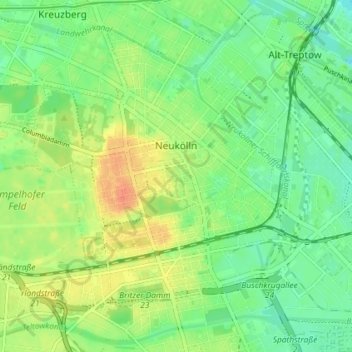
Name: Neukölln topographic map, elevation, terrain.
Location: Neukölln, Berlijn, Duitsland (52.45876 13.40608 52.49587 13.47855)
Average elevation: 43 m
Minimum elevation: 26 m
Maximum elevation: 67 m
Other topographic maps
Click on a map to view its topography, its elevation and its terrain.
Siemensstadt
Siemensstadt, Spandau, Berlijn, 13629, Duitsland
Average elevation: 35 m
Charlottenburg-Wilmersdorf
Charlottenburg-Wilmersdorf, Berlijn, Duitsland
Average elevation: 44 m
Lichterfelde
Lichterfelde, Steglitz-Zehlendorf, Berlijn, Duitsland
Average elevation: 47 m
Alt-Hohenschönhausen
Alt-Hohenschönhausen, Lichtenberg, Berlijn, Duitsland
Average elevation: 57 m