
Make a donation
Gear up for your next adventure:
As an Amazon Associate, this site earns from qualifying purchases at no extra cost to you.
Centreville topographic map
Click on the map to display elevation.
Make a donation
Gear up for your next adventure:
As an Amazon Associate, this site earns from qualifying purchases at no extra cost to you.
About this map
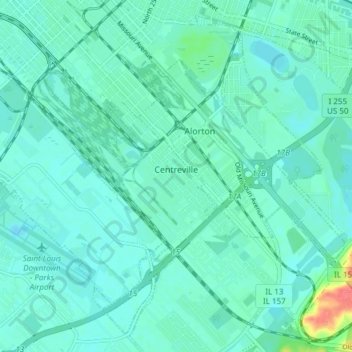
Name: Centreville topographic map, elevation, terrain.
Location: Centreville, Saint Clair County, Illinois, United States (38.55515 -90.14101 38.60927 -90.06552)
Average elevation: 127 m
Minimum elevation: 118 m
Maximum elevation: 171 m
Make a donation
Gear up for your next adventure:
As an Amazon Associate, this site earns from qualifying purchases at no extra cost to you.
Other topographic maps
Click on a map to view its topography, its elevation and its terrain.
Make a donation
Gear up for your next adventure:
As an Amazon Associate, this site earns from qualifying purchases at no extra cost to you.
Dutch Hollow
United States > Illinois > Saint Clair County > Belleville > Dutch Hollow
Average elevation: 170 m