Geolocate

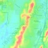
Helena topographic map

Click on the map to display elevation.

About this map
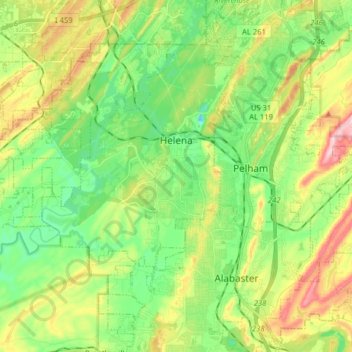
Name: Helena topographic map, elevation, terrain.

Location: Helena, Shelby County, Alabama, 35080, United States (33.23329 -86.97394 33.33216 -86.81505)

Average elevation: 163 m

Minimum elevation: 79 m

Maximum elevation: 309 m

Other topographic maps

Click on a map to view its topography, its elevation and its terrain.
Scottsdale

United States > Alabama > Shelby County > Alabaster

Average elevation: 168 m

Valley Forge

United States > Alabama > Shelby County > Alabaster

Average elevation: 152 m

Maylene

United States > Alabama > Shelby County > Alabaster

Average elevation: 179 m

Meadowbrook

United States > Alabama > Shelby County

Average elevation: 192 m

Chandalar South

United States > Alabama > Shelby County > Pelham

Average elevation: 160 m

Abbot Springs

United States > Alabama > Shelby County > Westover

Average elevation: 163 m

Lawley

United States > Alabama > Shelby County

Average elevation: 168 m

Westover

United States > Alabama > Shelby County

Average elevation: 153 m

Hardy

United States > Alabama > Shelby County > Alabaster

Average elevation: 157 m

Meadowbrook

United States > Alabama > Shelby County > Meadowbrook

Average elevation: 192 m

Gear up for your next adventure:

👖Convertible Hiking Pants - Zip-off legs to adapt to changing weather conditions
🧥Fleece Jacket - Warm and lightweight jacket for layering
⛺Lightweight Camping Tent - Portable shelter optimized for Canadian backcountry camping
🔦LED Headlamp - Hands-free lighting for early morning starts or late finishes
⛺Camping Tent - Weather-resistant tents suitable for 2 to 6 people

As an Amazon Associate, this site earns from qualifying purchases at no extra cost to you.