
Make a donation
Gear up for your next adventure:
As an Amazon Associate, this site earns from qualifying purchases at no extra cost to you.
La Palca topographic map
Click on the map to display elevation.
Make a donation
Gear up for your next adventure:
As an Amazon Associate, this site earns from qualifying purchases at no extra cost to you.
About this map
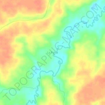
Name: La Palca topographic map, elevation, terrain.
Average elevation: 178 m
Minimum elevation: 153 m
Maximum elevation: 198 m
Make a donation
Gear up for your next adventure:
As an Amazon Associate, this site earns from qualifying purchases at no extra cost to you.
Other topographic maps
Click on a map to view its topography, its elevation and its terrain.
Ixiamas
Bolivia > La Paz > Provincia Abel Iturralde > Municipio Ixiamas
La región presenta una topografía plana a ondulada, con pendientes moderadas, comprendidas entre 0 y 5 %. La población de Ixiamas cuenta con un límite natural demarcado por el río Etaca y tiene un radio urbano de 2.500 m.
Average elevation: 251 m