Geolocate

Oy topographic map

Click on the map to display elevation.

About this map

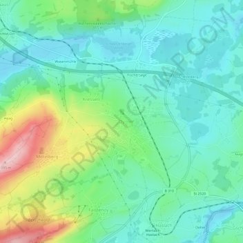
Name: Oy topographic map, elevation, terrain.

Location: Oy, Oy-Mittelberg, Landkreis Oberallgäu, Bavaria, 87466, Germany (47.62304 10.43376 47.66304 10.47376)

Average elevation: 918 m

Minimum elevation: 852 m

Maximum elevation: 1,095 m

Other topographic maps

Click on a map to view its topography, its elevation and its terrain.

Oberstdorf

Germany > Bavaria > Landkreis Oberallgäu

Average elevation: 1,490 m

Oberstdorf

Germany > Bavaria > Landkreis Oberallgäu

Average elevation: 1,490 m

Oy-Mittelberg

Germany > Bavaria > Landkreis Oberallgäu

Average elevation: 920 m

Waltenhofen

Germany > Bavaria > Landkreis Oberallgäu

Average elevation: 780 m

87534

Germany > Bavaria > Landkreis Oberallgäu > Oberstaufen

Average elevation: 1,065 m

Sonthofen

Germany > Bavaria > Landkreis Oberallgäu

Average elevation: 964 m

Ofterschwang

Germany > Bavaria > Landkreis Oberallgäu

Average elevation: 941 m

Weitnau

Germany > Bavaria > Landkreis Oberallgäu

• Argental Skilifte; Two ski lifts offer well-prepared pistes for beginners and seasoned skiers and snowboarders. The 500-metre-long family lift, a modern T-bar lift with a difference in altitude of 120 metres, was completely rebuilt in the early 2000s. In addition, there is a 100-metre beginners lift with a…

Average elevation: 887 m

Gear up for your next adventure:

🧣Evaporative Cooling Towel - Beat the heat during intense summer climbs
Lightweight Backpacking Tent - Compact tent for efficient hiking trips
Family Camping Tent - Spacious tent suitable for family camping trips
🧢Hiking Hat - Sun-protective and breathable hats for long treks
🥾Waterproof Hiking Boots - Essential footwear for rugged terrain and wet Canadian trails

As an Amazon Associate, this site earns from qualifying purchases at no extra cost to you.