
Make a donation
Gear up for your next adventure:
As an Amazon Associate, this site earns from qualifying purchases at no extra cost to you.
Arimont topographic map
Click on the map to display elevation.
Make a donation
Gear up for your next adventure:
As an Amazon Associate, this site earns from qualifying purchases at no extra cost to you.
About this map
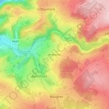
Name: Arimont topographic map, elevation, terrain.
Location: Arimont, Malmedy, Verviers, Luik, Wallonië, 4960, België (50.39897 6.04461 50.43897 6.08461)
Average elevation: 477 m
Minimum elevation: 336 m
Maximum elevation: 586 m
Make a donation
Gear up for your next adventure:
As an Amazon Associate, this site earns from qualifying purchases at no extra cost to you.
Other topographic maps
Click on a map to view its topography, its elevation and its terrain.
Bévercé
België > Luik > Verviers > Malmedy
Naast Bévercé zelf omvat de deelgemeente meer dan 15 kleinere dorpjes en gehuchten, waaronder de toeristische plaatsjes Mont en Xhoffraix. Op straat worden op de traditionele blauwe Belgische wegwijzers de weg naar deze gehuchten gezamenlijk aangegeven als Mont - Xhoffraix. In Bévercé ontspringt op 500…
Average elevation: 510 m