Geolocate

Mutanyi topographic map

Click on the map to display elevation.

About this map

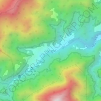
Name: Mutanyi topographic map, elevation, terrain.

Location: Mutanyi, Santa Marta, Magdalena, RAP Caribe, Colombia (11.07987 -73.89928 11.11987 -73.85928)

Average elevation: 799 m

Minimum elevation: 323 m

Maximum elevation: 1,665 m

Other topographic maps

Click on a map to view its topography, its elevation and its terrain.

Taganga

Colombia > Magdalena > Santa Marta

Average elevation: 116 m

Santa Marta

Colombia > Magdalena > Santa Marta

Average elevation: 214 m

Gear up for your next adventure:

🔭Compact Monocular - One-handed bird watching and trail spotting
🎒Hiking Backpack - Lightweight and ergonomic backpacks for day hikes or multi-day treks
🧥Waterproof Jacket - Lightweight rain jackets for hiking and outdoor activities
🧊Portable Cooler - Keep food and drinks cold during outdoor adventures
🧴Outdoor Sunscreen - High SPF protection for high-altitude UV exposure

As an Amazon Associate, this site earns from qualifying purchases at no extra cost to you.