
Make a donation
Gear up for your next adventure:
As an Amazon Associate, this site earns from qualifying purchases at no extra cost to you.
Zadov topographic map
Click on the map to display elevation.
Make a donation
Gear up for your next adventure:
As an Amazon Associate, this site earns from qualifying purchases at no extra cost to you.
About this map
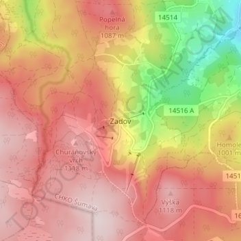
Name: Zadov topographic map, elevation, terrain.
Average elevation: 1,009 m
Minimum elevation: 771 m
Maximum elevation: 1,148 m
Make a donation
Gear up for your next adventure:
As an Amazon Associate, this site earns from qualifying purchases at no extra cost to you.
Other topographic maps
Click on a map to view its topography, its elevation and its terrain.
Make a donation
Gear up for your next adventure:
As an Amazon Associate, this site earns from qualifying purchases at no extra cost to you.
Kvilda
Czechia > Southwest > South Bohemian Region
Kvilda (German: Außergefild) is a municipality and village in Prachatice District in the South Bohemian Region of the Czech Republic. It has about 100 inhabitants. At an altitude of 1,065 metres (3,494 ft), it is the highest municipality in the Czech Republic. It is also one of the coldest places in the…
Average elevation: 1,095 m
Make a donation
Gear up for your next adventure:
As an Amazon Associate, this site earns from qualifying purchases at no extra cost to you.
Strakonice
Czechia > Southwest > South Bohemian Region
Strakonice is located about 51 kilometres (32 mi) northwest of České Budějovice. It lies mostly in the northern tip of the České Budějovice Basin, but the municipal territory also extends to the Blatná Uplands on the north and to the Bohemian Forest Foothills on the south. The highest point is the hill…
Average elevation: 448 m