
Make a donation
Gear up for your next adventure:
As an Amazon Associate, this site earns from qualifying purchases at no extra cost to you.
Federath topographic map
Click on the map to display elevation.
Make a donation
Gear up for your next adventure:
As an Amazon Associate, this site earns from qualifying purchases at no extra cost to you.
Federath
Federath ist ein Ortsteil von Marialinden in der Stadt Overath im Rheinisch-Bergischen Kreis in Nordrhein-Westfalen, Deutschland. Es liegt etwa 6 km östlich vom Kernbereich von Overath auf einer Höhe von 300 Metern.
Make a donation
Gear up for your next adventure:
As an Amazon Associate, this site earns from qualifying purchases at no extra cost to you.
About this map
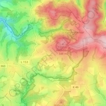
Name: Federath topographic map, elevation, terrain.
Average elevation: 268 m
Minimum elevation: 144 m
Maximum elevation: 376 m
Make a donation
Gear up for your next adventure:
As an Amazon Associate, this site earns from qualifying purchases at no extra cost to you.
Other topographic maps
Click on a map to view its topography, its elevation and its terrain.
Breidenassel
Deutschland > Nordrhein-Westfalen > Rheinisch-Bergischer Kreis > Overath
Average elevation: 182 m