
Make a donation
Gear up for your next adventure:
As an Amazon Associate, this site earns from qualifying purchases at no extra cost to you.
Torfhaus topographic map
Click on the map to display elevation.
Make a donation
Gear up for your next adventure:
As an Amazon Associate, this site earns from qualifying purchases at no extra cost to you.
About this map
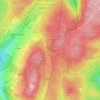
Name: Torfhaus topographic map, elevation, terrain.
Average elevation: 476 m
Minimum elevation: 384 m
Maximum elevation: 529 m
Make a donation
Gear up for your next adventure:
As an Amazon Associate, this site earns from qualifying purchases at no extra cost to you.
Other topographic maps
Click on a map to view its topography, its elevation and its terrain.
Silberborn
Deutschland > Niedersachsen > Landkreis Holzminden > Holzminden
Der Ortsteil Torfhaus, der aus wenigen Gebäuden besteht, liegt auf der Silberborner Hochebene 1,25 Kilometer östlich vom Silberborner Ortskern an der Landesstraße 549 auf etwa 490 m Höhe, womit er die höchstgelegene Ortschaft des Solling ist.
Average elevation: 449 m