
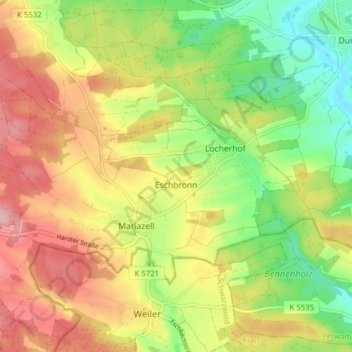
Eschbronn topographic map
Interactive map
Click on the map to display elevation.
About this map
Name: Eschbronn topographic map, elevation, terrain.
Average elevation: 713 m
Minimum elevation: 644 m
Maximum elevation: 784 m
The municipality (Gemeinde) of Eschbronn covers 11.41 square kilometers (4.41 sq mi) of the district of Rottweil, of the German state of Baden-Württemberg. Eschonbronn is physically located at the edge of the Central Black Forest and the Upper Gäu [de]. Elevation above sea level in the municipal area has a range of about 100 meters (330 ft), with a high of 772 meters (2,533 ft) Normalnull (NN) near Mariazell and a low of 670 meters (2,200 ft) NN at the Teufenbach on the border with Dunningen.[3]
Other topographic maps
Click on a map to view its topography, its elevation and its terrain.
Epfendorf
Germany > Baden-Württemberg > Landkreis Rottweil
Epfendorf, Verwaltungsgemeinschaft Oberndorf am Neckar, Landkreis Rottweil, Baden-Württemberg, 78736, Germany
Average elevation: 611 m
Schenkenzell
Germany > Baden-Württemberg > Landkreis Rottweil
Schenkenzell, Verwaltungsgemeinschaft Schiltach, Landkreis Rottweil, Baden-Württemberg, 77773, Germany
Average elevation: 603 m
Schramberg
Germany > Baden-Württemberg > Landkreis Rottweil
Schramberg, Verwaltungsgemeinschaft Schramberg, Landkreis Rottweil, Baden-Württemberg, Germany
Average elevation: 706 m