
Colwell topographic map
Click on the map to display elevation.
About this map
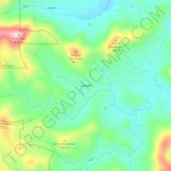
Name: Colwell topographic map, elevation, terrain.
Location: Colwell, Fannin County, Georgia, United States (34.87718 -84.49243 34.91718 -84.45243)
Average elevation: 630 m
Minimum elevation: 527 m
Maximum elevation: 863 m
Other topographic maps
Click on a map to view its topography, its elevation and its terrain.
Lake Blue Ridge
United States > Georgia > Fannin County > Morganton
As part of the Blue Ridge Dam Rehabilitation project, the Tennessee Valley Authority, began slowly lowering the elevation of Blue Ridge Lake in July 2010. This rehabilitation project aimed to repair the dam penstock and to stabilize both the upstream and downstream faces of the dam. The project reduced the…
Average elevation: 572 m