Geolocate

Mingo topographic map

Click on the map to display elevation.

About this map

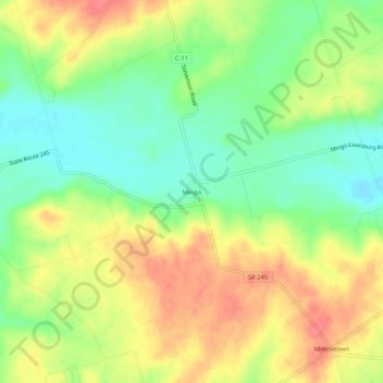
Name: Mingo topographic map, elevation, terrain.

Location: Mingo, Champaign County, Ohio, 43047, United States (40.18811 -83.65826 40.22811 -83.61826)

Average elevation: 387 m

Minimum elevation: 354 m

Maximum elevation: 421 m

Other topographic maps

Click on a map to view its topography, its elevation and its terrain.

North Lewisburg

United States > Ohio > Champaign County

Average elevation: 335 m

Woodstock

United States > Ohio > Champaign County

Average elevation: 320 m

Mutual

United States > Ohio > Champaign County

Average elevation: 367 m

Mechanicsburg

United States > Ohio > Champaign County

Average elevation: 332 m

Mad River

United States > Ohio > Champaign County > West Liberty

Average elevation: 337 m

St. Paris

United States > Ohio > Champaign County

Average elevation: 373 m

Christiansburg

United States > Ohio > Champaign County

Average elevation: 342 m

Gear up for your next adventure:

🧥Ultralight Puffy Jacket - Maximum warmth that packs down to the size of an orange
🧢Sun Hat - Wide-brim hat for sun protection
🛶Waterproof Dry Bags - Keep electronics and clothes dry during river crossings
🚲MTB Frame Bag - Carry tools and maps directly on your bicycle frame
🧥Fleece Jacket - Warm and lightweight jacket for layering

As an Amazon Associate, this site earns from qualifying purchases at no extra cost to you.