
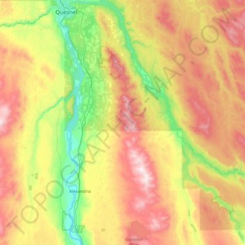
Area A (Red Bluff/Quesnel South) topographic map
Interactive map
Click on the map to display elevation.
About this map
Name: Area A (Red Bluff/Quesnel South) topographic map, elevation, terrain.
Average elevation: 854 m
Minimum elevation: 423 m
Maximum elevation: 1,475 m
Cariboo Regional District trails, hiking, mountain biking, running and outdoor activities
Other topographic maps
Click on a map to view its topography, its elevation and its terrain.
Elbow Lake
Canada > British Columbia > Cariboo Regional District > Area F (Horsefly/Likely/150 Mile House)
Average elevation: 959 m
Map Glacier
Canada > British Columbia > Cariboo Regional District > Area J (West Chilcotin)
Average elevation: 2,037 m
Great Canyon
Canada > British Columbia > Cariboo Regional District > Area J (West Chilcotin)
Average elevation: 1,220 m
Antler Creek
Canada > British Columbia > Cariboo Regional District > Area C (Bowron Lake/Barlow Creek/Barkerville)
Average elevation: 1,021 m
Mount Juno
Canada > British Columbia > Cariboo Regional District > Area J (West Chilcotin)
Average elevation: 2,219 m
Blue Lake
Canada > British Columbia > Cariboo Regional District > Area A (Red Bluff/Quesnel South)
Average elevation: 781 m
Black Lake
Canada > British Columbia > Cariboo Regional District > Area C (Bowron Lake/Barlow Creek/Barkerville)
Average elevation: 1,705 m
Great Canyon
Canada > British Columbia > Cariboo Regional District > Area J (West Chilcotin)
Average elevation: 1,220 m
Anahim Lake
Canada > British Columbia > Cariboo Regional District > Area J (West Chilcotin)
Average elevation: 1,101 m
Alexis Creek
Canada > British Columbia > Cariboo Regional District > Area K (East Chilcotin)
Average elevation: 814 m
Whitestone Lake
Canada > British Columbia > Cariboo Regional District > Area D (Commodore Heights/McLeese Lake)
Average elevation: 848 m
Lac La Hache
Canada > British Columbia > Cariboo Regional District > Area G (Lac La Hache/108 Mile Ranch)
Average elevation: 847 m
Heckman Pass
Canada > British Columbia > Cariboo Regional District > Area J (West Chilcotin)
Average elevation: 1,519 m
Twan Lake
Canada > British Columbia > Cariboo Regional District > Area K (East Chilcotin)
Average elevation: 941 m
150 Mile House
Canada > British Columbia > Cariboo Regional District > Area F (Horsefly/Likely/150 Mile House)
Average elevation: 789 m
Lone Butte
Canada > British Columbia > Cariboo Regional District > Area L (Lone Butte/Interlakes)
The northward advance of the Pacific Great Eastern Railway (PGE) rail head passed through Lone Butte in late April 1919. This construction camp had a large kitchen employing 25 cooks, of whom two received the Distinguished Conduct Medal and three the Military Medal during World War I. At an elevation of about…
Average elevation: 1,159 m
Horse Lake
Canada > British Columbia > Cariboo Regional District > Area K (East Chilcotin)
Average elevation: 1,938 m
Cottonwood River
Canada > British Columbia > Cariboo Regional District > Area C (Bowron Lake/Barlow Creek/Barkerville)
Average elevation: 799 m
Bouchie Lake
Canada > British Columbia > Cariboo Regional District > Area B (Quesnel West/Bouchie Lake)
Average elevation: 699 m
Deka Lake
Canada > British Columbia > Cariboo Regional District > Area L (Lone Butte/Interlakes)
Average elevation: 1,141 m
Barkerville
Canada > British Columbia > Cariboo Regional District > Area C (Bowron Lake/Barlow Creek/Barkerville)
Barkerville has a subarctic climate (Köppen climate classification Dfc), which makes it have long, cold and snowy winter and short and cool summers due to its high altitude and latitude. Its growing season averages only 66 days.
Average elevation: 1,435 m
Canim Lake
Canada > British Columbia > Cariboo Regional District > Area H (Canim Lake/Forest Grove)
Average elevation: 936 m
Polley Lake
Canada > British Columbia > Cariboo Regional District > Area F (Horsefly/Likely/150 Mile House)
Average elevation: 1,022 m
Riske Creek
Canada > British Columbia > Cariboo Regional District > Area K (East Chilcotin)
Average elevation: 953 m
Puntzi Mountain
Canada > British Columbia > Cariboo Regional District > Area J (West Chilcotin)
Average elevation: 1,293 m
Nimpo Lake
Canada > British Columbia > Cariboo Regional District > Area J (West Chilcotin)
Average elevation: 1,131 m
Forest Grove
Canada > British Columbia > Cariboo Regional District > Area H (Canim Lake/Forest Grove)
Average elevation: 917 m
Williams Lake
Canada > British Columbia > Cariboo Regional District > Williams Lake
Average elevation: 854 m
Nazko
Canada > British Columbia > Cariboo Regional District > Area I (West Fraser/Nazko)
Average elevation: 891 m
The Joker
Canada > British Columbia > Cariboo Regional District > Area J (West Chilcotin)
Average elevation: 2,157 m
Likely
Canada > British Columbia > Cariboo Regional District > Area F (Horsefly/Likely/150 Mile House)
Average elevation: 885 m
Anahim Peak
Canada > British Columbia > Cariboo Regional District > Area J (West Chilcotin)
Average elevation: 1,416 m