
Make a donation
Gear up for your next adventure:
As an Amazon Associate, this site earns from qualifying purchases at no extra cost to you.
Khenchela topographic map
Click on the map to display elevation.
Make a donation
Gear up for your next adventure:
As an Amazon Associate, this site earns from qualifying purchases at no extra cost to you.
Khenchela
Khenchela (en tamazight: ⵅⴰⵏⵛⵍⴰ, Xencelt; en arabe : خنشلة), antique Mascula, est une commune d'Algérie et le chef-lieu de la wilaya de Khenchela. Située dans les Aurès, elle se trouve à 1 122 m d'altitude moyenne. La population de la ville est d'environ 108 580 habitants lors du dernier recensement de 2008.
Make a donation
Gear up for your next adventure:
As an Amazon Associate, this site earns from qualifying purchases at no extra cost to you.
About this map
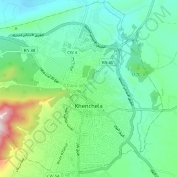
Name: Khenchela topographic map, elevation, terrain.
Location: Khenchela, Daïra de Djanet, Khenchela, Algérie (35.40649 7.10277 35.46579 7.17705)
Average elevation: 1,116 m
Minimum elevation: 971 m
Maximum elevation: 1,552 m
Make a donation
Gear up for your next adventure:
As an Amazon Associate, this site earns from qualifying purchases at no extra cost to you.