Geolocate

Mellen topographic map

Click on the map to display elevation.

About this map

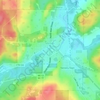
Name: Mellen topographic map, elevation, terrain.

Location: Mellen, Ashland County, Wisconsin, 54546, United States (46.31300 -90.67379 46.33487 -90.64607)

Average elevation: 395 m

Minimum elevation: 367 m

Maximum elevation: 442 m

Other topographic maps

Click on a map to view its topography, its elevation and its terrain.

La Pointe

United States > Wisconsin > Ashland County

Average elevation: 186 m

Highbridge

United States > Wisconsin > Ashland County

Average elevation: 295 m

Glidden

United States > Wisconsin > Ashland County

Average elevation: 468 m

Morgan Falls

United States > Wisconsin > Ashland County

Average elevation: 402 m

Marengo

United States > Wisconsin > Ashland County

Average elevation: 240 m

Gear up for your next adventure:

🧥Softshell Jacket - Windproof and breathable jacket for hiking
🧥Ultralight Puffy Jacket - Maximum warmth that packs down to the size of an orange
Tent Footprint - Protect tent floor and increase durability
🧤Thermal Hiking Gloves - Grip-enhanced gloves for cold-weather altitude trekking
🛶Waterproof Dry Bags - Keep electronics and clothes dry during river crossings

As an Amazon Associate, this site earns from qualifying purchases at no extra cost to you.