
Thank you for supporting this site ❤️
Make a donation
Make a donation
Gear up for your next adventure:
As an Amazon Associate, this site earns from qualifying purchases at no extra cost to you.
Jancao topographic map
Click on the map to display elevation.
Thank you for supporting this site ❤️
Make a donation
Make a donation
Gear up for your next adventure:
As an Amazon Associate, this site earns from qualifying purchases at no extra cost to you.
About this map
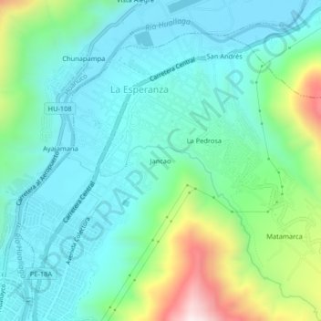
Name: Jancao topographic map, elevation, terrain.
Location: Jancao, Amarilis, Huánuco, 10002, Perú (-9.92197 -76.23663 -9.88197 -76.19663)
Average elevation: 2,033 m
Minimum elevation: 1,842 m
Maximum elevation: 2,641 m
Thank you for supporting this site ❤️
Make a donation
Make a donation
Gear up for your next adventure:
As an Amazon Associate, this site earns from qualifying purchases at no extra cost to you.