Geolocate

Cayabu topographic map

Click on the map to display elevation.

About this map

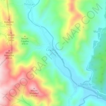
Name: Cayabu topographic map, elevation, terrain.

Location: Cayabu, Tanay, Rizal, Calabarzon, Philippines (14.64160 121.32336 14.68160 121.36336)

Average elevation: 401 m

Minimum elevation: 218 m

Maximum elevation: 737 m

Other topographic maps

Click on a map to view its topography, its elevation and its terrain.

Tanay River

Philippines > Rizal > Tanay > Little Ville

Average elevation: 34 m

Gear up for your next adventure:

🧭Orienteering Kit - Tools for map reading and navigation in the wild
👟Sport Hiking Sandals - Breathable footwear for water crossings and camp rest
🧦Merino Wool Socks - Moisture-wicking comfort for long-distance hiking
🔥Camping Stove - Portable stoves to cook outdoors with ease
🥾Waterproof Hiking Boots - Essential footwear for rugged terrain and wet Canadian trails

As an Amazon Associate, this site earns from qualifying purchases at no extra cost to you.