
Make a donation
Gear up for your next adventure:
As an Amazon Associate, this site earns from qualifying purchases at no extra cost to you.
Neurath topographic map
Click on the map to display elevation.
Make a donation
Gear up for your next adventure:
As an Amazon Associate, this site earns from qualifying purchases at no extra cost to you.
Neurath
Neurath liegt südwestlich der Burg Stahleck und am Fuße des Rabenkopfes (395 m ü. NHN) in 240 m Höhe auf der linken Hochfläche des Oberen Mittelrheintales am östlichen Ende des Hunsrück. Der Ort ist mit dem ein Kilometer nördlich am Rheinufer gelegenen Hauptort durch die Kreisstraße 24 Bacharach–Manubach verbunden. Das Gebiet von Neurath wird für Wein- und Ackerbau genutzt, ein Teil ist bewaldet.
Make a donation
Gear up for your next adventure:
As an Amazon Associate, this site earns from qualifying purchases at no extra cost to you.
About this map
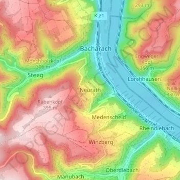
Name: Neurath topographic map, elevation, terrain.
Average elevation: 235 m
Minimum elevation: 71 m
Maximum elevation: 398 m
Make a donation
Gear up for your next adventure:
As an Amazon Associate, this site earns from qualifying purchases at no extra cost to you.