
Make a donation
Gear up for your next adventure:
As an Amazon Associate, this site earns from qualifying purchases at no extra cost to you.
Roscoe Township topographic map
Click on the map to display elevation.
Make a donation
Gear up for your next adventure:
As an Amazon Associate, this site earns from qualifying purchases at no extra cost to you.
About this map
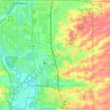
Name: Roscoe Township topographic map, elevation, terrain.
Location: Roscoe Township, Winnebago County, Illinois, United States (42.38996 -89.05976 42.49613 -88.93919)
Average elevation: 248 m
Minimum elevation: 215 m
Maximum elevation: 298 m
Make a donation
Gear up for your next adventure:
As an Amazon Associate, this site earns from qualifying purchases at no extra cost to you.
Other topographic maps
Click on a map to view its topography, its elevation and its terrain.
Rock Cut State Park
United States > Illinois > Winnebago County > Machesney Park
Average elevation: 265 m
Make a donation
Gear up for your next adventure:
As an Amazon Associate, this site earns from qualifying purchases at no extra cost to you.