Geolocate

Johnson topographic map

Click on the map to display elevation.

About this map

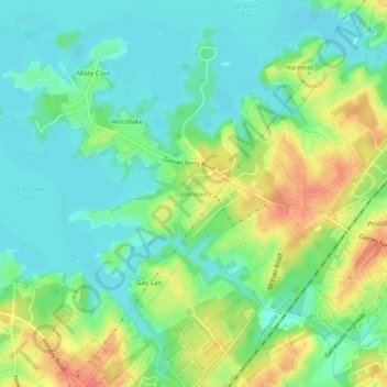
Name: Johnson topographic map, elevation, terrain.

Location: Johnson, Hall County, Georgia, United States (34.15232 -83.99074 34.19232 -83.95074)

Average elevation: 341 m

Minimum elevation: 322 m

Maximum elevation: 374 m

Other topographic maps

Click on a map to view its topography, its elevation and its terrain.

Gainesville

United States > Georgia > Hall County

Average elevation: 346 m

Deaton Creek

United States > Georgia > Hall County

Average elevation: 277 m

Oakwood

United States > Georgia > Hall County

Average elevation: 358 m

Gainesville

United States > Georgia > Hall County

Average elevation: 346 m

Flowery Branch

United States > Georgia > Hall County

Average elevation: 343 m

Lula

United States > Georgia > Hall County

Average elevation: 369 m

Lula

United States > Georgia > Hall County

Average elevation: 369 m

Gainesville

United States > Georgia > Hall County

Average elevation: 346 m

Gear up for your next adventure:

🔋Lithium AA Batteries - Long-lasting power that performs in extreme cold
🪑Insulated Seat Pad - Protect your seat from cold rocks and wet logs
🧢Outdoor Visor - Breathable visor for sunny hikes
🥾Approach Boots - Comfortable boots for hiking and climbing approaches
🥾Waterproof Hiking Boots - Boots keeping your feet dry in wet conditions

As an Amazon Associate, this site earns from qualifying purchases at no extra cost to you.