Geolocate

Eirexe topographic map

Click on the map to display elevation.

About this map

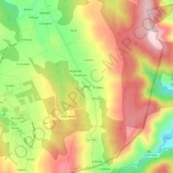
Name: Eirexe topographic map, elevation, terrain.

Location: Eirexe, Milleirós, Pol, Meira, Lugo, Galicia, 27275, España (43.11021 -7.29885 43.15021 -7.25885)

Average elevation: 647 m

Minimum elevation: 436 m

Maximum elevation: 829 m

Other topographic maps

Click on a map to view its topography, its elevation and its terrain.

Mosteiro

España > Galicia > Meira > Pol

Average elevation: 513 m

Milleirós

España > Galicia > Meira > Pol

Average elevation: 656 m

Gear up for your next adventure:

🦌Outdoor Trail Camera - Monitor wildlife activity near your favorite spots
🏕️Camping Hammock - Integrated protection for sleeping between trees
🔋Solar Power Bank - Keep your GPS and devices charged during long outdoor trips
👟Sport Hiking Sandals - Breathable footwear for water crossings and camp rest
🎒Fully Waterproof Backpack - Total protection for photography gear and electronics

As an Amazon Associate, this site earns from qualifying purchases at no extra cost to you.