
Make a donation
Gear up for your next adventure:
As an Amazon Associate, this site earns from qualifying purchases at no extra cost to you.
Branoux-les-Taillades topographic map
Click on the map to display elevation.
Make a donation
Gear up for your next adventure:
As an Amazon Associate, this site earns from qualifying purchases at no extra cost to you.
About this map
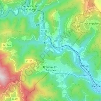
Name: Branoux-les-Taillades topographic map, elevation, terrain.
Average elevation: 385 m
Minimum elevation: 183 m
Maximum elevation: 838 m
Make a donation
Gear up for your next adventure:
As an Amazon Associate, this site earns from qualifying purchases at no extra cost to you.
Other topographic maps
Click on a map to view its topography, its elevation and its terrain.
Coste Belle
Frankrijk > Occitanië > Gard > Vers-Pont-du-Gard > Vers-Pont-du-Gard
Average elevation: 78 m
Moure de Pujol
Frankrijk > Occitanië > Gard > Castillon-du-Gard > Castillon-du-Gard/Castelhon de Gard
Average elevation: 48 m
Make a donation
Gear up for your next adventure:
As an Amazon Associate, this site earns from qualifying purchases at no extra cost to you.
Make a donation
Gear up for your next adventure:
As an Amazon Associate, this site earns from qualifying purchases at no extra cost to you.