Geolocate

Arma topographic map

Click on the map to display elevation.

About this map

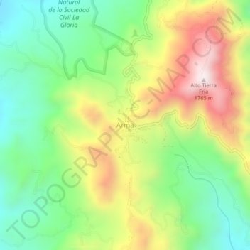
Name: Arma topographic map, elevation, terrain.

Location: Arma, Aguadas, Norte, Caldas, Colombia (5.59524 -75.56014 5.63524 -75.52014)

Average elevation: 1,299 m

Minimum elevation: 985 m

Maximum elevation: 1,757 m

Gear up for your next adventure:

🧢Hiking Sun Hat - Wide-brimmed protection for exposed mountain ridges
🕶️Polarized Sunglasses - Reduces glare from snow and water at high elevations
🧴Bear Spray Holster - Quick-access carry for essential Canadian wilderness safety
🛌Insulated Sleeping Pad - Critical thermal barrier between you and the cold ground
🥾Trail Hiking Shoes - Durable shoes designed for rugged trails

As an Amazon Associate, this site earns from qualifying purchases at no extra cost to you.