
Thank you for supporting this site ❤️
Make a donation
Make a donation
Gear up for your next adventure:
As an Amazon Associate, this site earns from qualifying purchases at no extra cost to you.
La Côte-d'Aime topographic map
Click on the map to display elevation.
Thank you for supporting this site ❤️
Make a donation
Make a donation
Gear up for your next adventure:
As an Amazon Associate, this site earns from qualifying purchases at no extra cost to you.
About this map
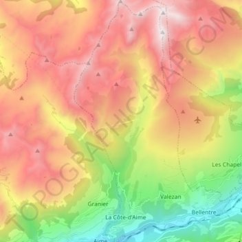
Name: La Côte-d'Aime topographic map, elevation, terrain.
Average elevation: 1,827 m
Minimum elevation: 663 m
Maximum elevation: 2,954 m
Thank you for supporting this site ❤️
Make a donation
Make a donation
Gear up for your next adventure:
As an Amazon Associate, this site earns from qualifying purchases at no extra cost to you.
Other topographic maps
Click on a map to view its topography, its elevation and its terrain.
Plagne Villages
Frankrijk > Auvergne-Rhône-Alpes > Savoie > La Plagne-Tarentaise
Average elevation: 2,104 m
Les Chacruets
Frankrijk > Auvergne-Rhône-Alpes > Savoie > La Plagne-Tarentaise
Average elevation: 1,109 m