
Make a donation
Gear up for your next adventure:
As an Amazon Associate, this site earns from qualifying purchases at no extra cost to you.
Koltershäuschen topographic map
Click on the map to display elevation.
Make a donation
Gear up for your next adventure:
As an Amazon Associate, this site earns from qualifying purchases at no extra cost to you.
Koltershäuschen
Koltershäuschen liegt östlich des Leichlinger Zentrums auf einem Höhenrücken zwischen dem Murbach und dem Weltersbach an der Landesstraße 294 nahe der Stadtgrenze zu Leverkusen und zu Burscheid.
Make a donation
Gear up for your next adventure:
As an Amazon Associate, this site earns from qualifying purchases at no extra cost to you.
About this map
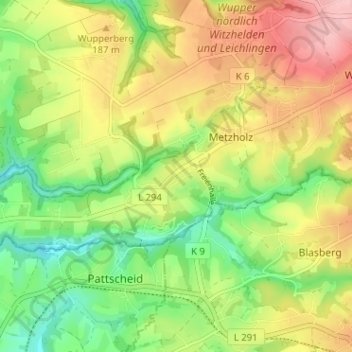
Name: Koltershäuschen topographic map, elevation, terrain.
Average elevation: 161 m
Minimum elevation: 91 m
Maximum elevation: 243 m
Make a donation
Gear up for your next adventure:
As an Amazon Associate, this site earns from qualifying purchases at no extra cost to you.
Other topographic maps
Click on a map to view its topography, its elevation and its terrain.
42799
Deutschland > Nordrhein-Westfalen > Rheinisch-Bergischer Kreis > Leichlingen > Metzholz > Koltershäuschen
Average elevation: 143 m