Geolocate

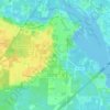
Wallace topographic map

Click on the map to display elevation.

About this map

Name: Wallace topographic map, elevation, terrain.

Location: Wallace, Santa Rosa County, Florida, United States (30.65741 -87.19997 30.69741 -87.15997)

Average elevation: 51 m

Minimum elevation: 21 m

Maximum elevation: 67 m

Other topographic maps

Click on a map to view its topography, its elevation and its terrain.

Bagdad

United States > Florida > Santa Rosa County

Average elevation: 10 m

Gear up for your next adventure:

🥾Waterproof Hiking Boots - Essential footwear for rugged terrain and wet Canadian trails
🩹Compact First Aid Kit - Pre-packed essentials for common trail injuries
🧢Hiking Sun Hat - Wide-brimmed protection for exposed mountain ridges
🧴Outdoor Sunscreen - High SPF protection for high-altitude UV exposure
🧥Softshell Hiking Jacket - The perfect balance of wind protection and breathability

As an Amazon Associate, this site earns from qualifying purchases at no extra cost to you.