
Make a donation
Gear up for your next adventure:
As an Amazon Associate, this site earns from qualifying purchases at no extra cost to you.
Sohlen topographic map
Click on the map to display elevation.
Make a donation
Gear up for your next adventure:
As an Amazon Associate, this site earns from qualifying purchases at no extra cost to you.
About this map
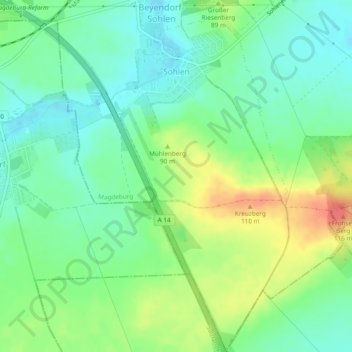
Name: Sohlen topographic map, elevation, terrain.
Average elevation: 76 m
Minimum elevation: 55 m
Maximum elevation: 113 m
Make a donation
Gear up for your next adventure:
As an Amazon Associate, this site earns from qualifying purchases at no extra cost to you.
Other topographic maps
Click on a map to view its topography, its elevation and its terrain.
Magdeburg
Deutschland > Sachsen-Anhalt > Magdeburg
Die kreisfreie Stadt im Zentrum Sachsen-Anhalts liegt an der mittleren Elbe und am Ostrand der Landschaft Magdeburger Börde auf altem Kulturboden und bildet das Zentrum der Region Magdeburg (auch Elbe-Börde-Heide genannt). Als Ortsmittelpunkt für die Bestimmung der Lage Magdeburgs gilt der Fußpunkt der…
Average elevation: 71 m
Make a donation
Gear up for your next adventure:
As an Amazon Associate, this site earns from qualifying purchases at no extra cost to you.