
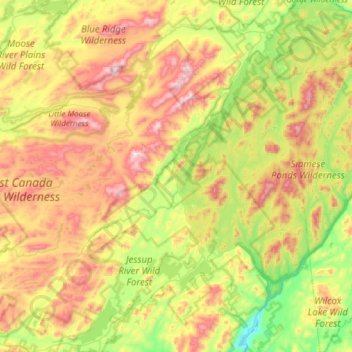
Town of Lake Pleasant topographic map
Interactive map
Click on the map to display elevation.
About this map
Name: Town of Lake Pleasant topographic map, elevation, terrain.
Average elevation: 640 m
Minimum elevation: 298 m
Maximum elevation: 1,160 m
Other topographic maps
Click on a map to view its topography, its elevation and its terrain.
Whitney Lake
United States > New York > Hamilton County > Town of Arietta
Whitney Lake, Town of Arietta, Hamilton County, New York, United States
Average elevation: 763 m
Cedar River
United States > New York > Hamilton County > Town of Indian Lake
Cedar River, Town of Indian Lake, Hamilton County, New York, United States
Average elevation: 620 m
Carpenter Hill
United States > New York > Hamilton County > Town of Lake Pleasant
Carpenter Hill, Town of Lake Pleasant, Hamilton County, New York, United States
Average elevation: 554 m
Town of Indian Lake
United States > New York > Hamilton County
Town of Indian Lake, Hamilton County, New York, United States
Average elevation: 625 m
Three Sisters Mountain
United States > New York > Hamilton County > Town of Arietta
Three Sisters Mountain, Town of Arietta, Hamilton County, New York, United States
Average elevation: 537 m
Long Lake
United States > New York > Hamilton County > Town of Long Lake
Long Lake, Town of Long Lake, Hamilton County, New York, United States
Average elevation: 611 m
Town of Inlet
United States > New York > Hamilton County
Town of Inlet, Hamilton County, New York, 13360, United States
Average elevation: 600 m