Geolocate

Cherai topographic map

Click on the map to display elevation.

About this map

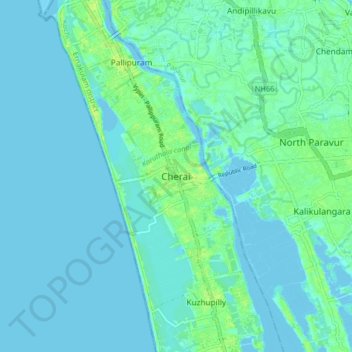
Name: Cherai topographic map, elevation, terrain.

Location: Cherai, Kochi, Ernakulam District, Kerala, 683514, India (10.10070 76.15358 10.18070 76.23358)

Average elevation: 3 m

Minimum elevation: -3 m

Maximum elevation: 13 m

Other topographic maps

Click on a map to view its topography, its elevation and its terrain.

Vypin

India > Kerala > Kochi > Edavanakkad

Average elevation: 3 m

Elamkunnapuzha

India > Kerala > Kochi > Elamkunnapuzha

Average elevation: 2 m

Gear up for your next adventure:

🔥Camping Stove - Portable stoves to cook outdoors with ease
🧤Thermal Hiking Gloves - Grip-enhanced gloves for cold-weather altitude trekking
🧥Packable Rain Jacket - Breathable waterproof layer for unpredictable weather
🧴Waterproofing Spray - Restore the DWR coating on jackets and tents
🥾Light Hiking Boots - Lightweight and comfortable boots for day hikes

As an Amazon Associate, this site earns from qualifying purchases at no extra cost to you.