Geolocate

Astino topographic map

Click on the map to display elevation.

About this map
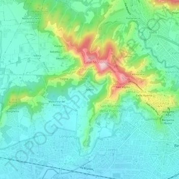
Name: Astino topographic map, elevation, terrain.

Location: Astino, Bergamo, Lombardia, 24129, Italia (45.68701 9.62003 45.72701 9.66003)

Average elevation: 294 m

Minimum elevation: 228 m

Maximum elevation: 497 m

Other topographic maps

Click on a map to view its topography, its elevation and its terrain.

Parco Suardi

Italia > Lombardia > Bergamo > Bergamo

Average elevation: 273 m

Gear up for your next adventure:

🧼Travel Hand Sanitizer - Keep hands clean when water is scarce
🚲Heavy Duty Bike Lock - Secure your bike at the trailhead or during stops
🧢Hiking Hat - Sun-protective and breathable hats for long treks
🧦Thermal Socks - Warm socks for winter hiking or camping
💡LED Camping Lantern - Illuminate your campsite with long-lasting lanterns

As an Amazon Associate, this site earns from qualifying purchases at no extra cost to you.