
Thank you for supporting this site ❤️
Make a donation
Make a donation
Gear up for your next adventure:
As an Amazon Associate, this site earns from qualifying purchases at no extra cost to you.
Tabarka topographic map
Click on the map to display elevation.
Thank you for supporting this site ❤️
Make a donation
Make a donation
Gear up for your next adventure:
As an Amazon Associate, this site earns from qualifying purchases at no extra cost to you.
About this map
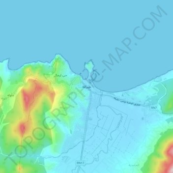
Name: Tabarka topographic map, elevation, terrain.
Location: Tabarka, طبرقة, معتمدية طبرقة, Jendouba, Tunisia (36.91456 8.71738 36.99456 8.79738)
Average elevation: 46 m
Minimum elevation: -3 m
Maximum elevation: 434 m
Thank you for supporting this site ❤️
Make a donation
Make a donation
Gear up for your next adventure:
As an Amazon Associate, this site earns from qualifying purchases at no extra cost to you.