Geolocate

Lindero topographic map

Click on the map to display elevation.

About this map

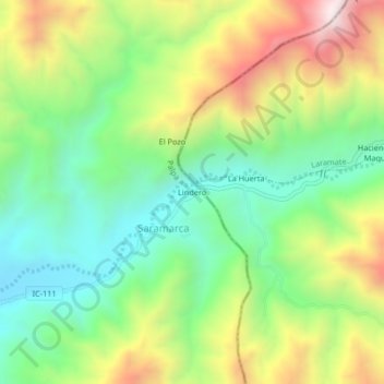
Name: Lindero topographic map, elevation, terrain.

Location: Lindero, Saramarca, Palpa, Province of Palpa, Ica, Peru (-14.50879 -75.11661 -14.46879 -75.07661)

Average elevation: 896 m

Minimum elevation: 539 m

Maximum elevation: 1,458 m

Gear up for your next adventure:

Family Camping Tent - Spacious tent suitable for family camping trips
🔦UV Flashlight - Detect minerals or specific insects in the dark
👟Leg Gaiters - Keep debris, mud, and snow out of your boots
🧥Softshell Jacket - Windproof and breathable jacket for hiking
🧥Insulated Jacket - Keep warm in cold outdoor conditions

As an Amazon Associate, this site earns from qualifying purchases at no extra cost to you.