
Make a donation
Gear up for your next adventure:
As an Amazon Associate, this site earns from qualifying purchases at no extra cost to you.
Niedershausen topographic map
Click on the map to display elevation.
Make a donation
Gear up for your next adventure:
As an Amazon Associate, this site earns from qualifying purchases at no extra cost to you.
About this map
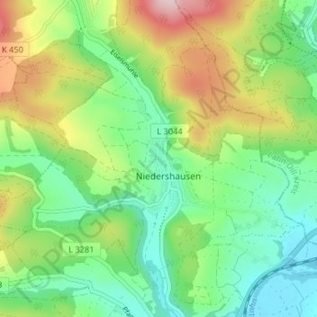
Name: Niedershausen topographic map, elevation, terrain.
Average elevation: 227 m
Minimum elevation: 132 m
Maximum elevation: 404 m
Make a donation
Gear up for your next adventure:
As an Amazon Associate, this site earns from qualifying purchases at no extra cost to you.
Other topographic maps
Click on a map to view its topography, its elevation and its terrain.
Selters
Deutschland > Hessen > Landkreis Limburg-Weilburg > Löhnberg
Der Grundstein der Kirche wurde am 21. Mai 1731 gelegt. Sie hat einen rechteckigen Grundriss, ein stattliches Krüppelwalmdach und einen verschieferten Dachreiter. Der Baumeister war der Zimmermeister J. A. Klöckner. Typisch für seine Arbeiten ist der Giebelturm, der sehr harmonisch in dreifacher Abstufung…
Average elevation: 191 m