Geolocate

Hanover topographic map

Click on the map to display elevation.

About this map

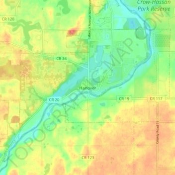
Name: Hanover topographic map, elevation, terrain.

Location: Hanover, Wright County, Minnesota, 55341, United States (45.13759 -93.70715 45.17420 -93.62978)

Average elevation: 291 m

Minimum elevation: 267 m

Maximum elevation: 313 m

Gear up for your next adventure:

🧦Outdoor Socks - Durable socks designed for hiking and outdoor sports
🛰️Satellite Messenger - Emergency communication for areas with no cell service
🧤Thermal Hiking Gloves - Grip-enhanced gloves for cold-weather altitude trekking
🎒Backpack Rain Cover - External shield to keep your entire pack dry
🔦LED Headtorch - Bright and durable light for night activities

As an Amazon Associate, this site earns from qualifying purchases at no extra cost to you.