Geolocate

Sion topographic map

Click on the map to display elevation.

About this map

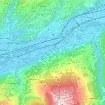
Name: Sion topographic map, elevation, terrain.

Location: Sion, Wallis, 1950, Switzerland (46.17805 7.30536 46.25585 7.42527)

Average elevation: 887 m

Minimum elevation: 476 m

Maximum elevation: 2,222 m

Other topographic maps

Click on a map to view its topography, its elevation and its terrain.

Vallée du Rhône

Switzerland > Wallis > Sion

Average elevation: 1,746 m

Vallée du Rhône

Switzerland > Wallis > Sion

Average elevation: 1,746 m

Sex Noir

Switzerland > Wallis > Sion > Arbaz

Average elevation: 2,290 m

Les Mountons

Switzerland > Wallis > Sion > Savièse

Average elevation: 2,228 m

Gear up for your next adventure:

Camping Essentials - All-in-one gear for a comfortable camping trip
🥾Waterproof Hiking Boots - Essential footwear for rugged terrain and wet Canadian trails
🧴Sunscreen SPF - Broad-spectrum sunscreen for outdoor activities
🧭GPS Outdoor Watch - Smart watch for navigation and fitness tracking in nature
🧦Merino Wool Socks - Moisture-wicking comfort for long-distance hiking

As an Amazon Associate, this site earns from qualifying purchases at no extra cost to you.