Geolocate

Poblacion topographic map

Click on the map to display elevation.

About this map

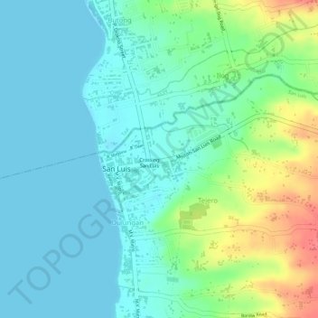
Name: Poblacion topographic map, elevation, terrain.

Location: Poblacion, San Luis, Batangas, Calabarzon, Philippines (13.85270 120.91465 13.85867 120.92774)

Average elevation: 20 m

Minimum elevation: 0 m

Maximum elevation: 69 m

Other topographic maps

Click on a map to view its topography, its elevation and its terrain.

San Isidro

Philippines > Batangas > San Luis

Average elevation: 148 m

Luya

Philippines > Batangas > San Luis

Average elevation: 125 m

Tejero

Philippines > Batangas > San Luis

Average elevation: 47 m

Luyong

Philippines > Batangas > San Luis > Luya

Average elevation: 153 m

Calumpang East

Philippines > Batangas > San Luis

Average elevation: 161 m

Tejero

Philippines > Batangas > San Luis

Average elevation: 47 m

Gear up for your next adventure:

🔨Vehicle Emergency Tool - Safety tool for remote road trips to trailheads
💧Hydration Pack - Hands-free hydration system for long hikes
🧣Merino Neck Gaiter - Protects against wind, sun, and cold at high altitudes
🧳Compression Sacks - Maximize space in your backpack by shrinking gear
Camping Essentials - All-in-one gear for a comfortable camping trip

As an Amazon Associate, this site earns from qualifying purchases at no extra cost to you.