
Ciburial topographic map
Click on the map to display elevation.
About this map
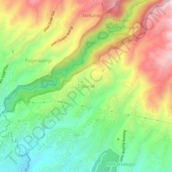
Name: Ciburial topographic map, elevation, terrain.
Average elevation: 1,006 m
Minimum elevation: 770 m
Maximum elevation: 1,311 m
Other topographic maps
Click on a map to view its topography, its elevation and its terrain.
Kolam Retensi Cieunteung
Indonesia > West Java > Kabupaten Bandung > Baleendah > Citeureup
Average elevation: 663 m
Patenggang Lake
Indonesia > West Java > Kabupaten Bandung > Rancabali > Bauan
Patenggang Lake (Indonesian: Situ Patenggang) is a lake located in the area of natural tourist attractions in the southern Bandung City, West Java, Indonesia, to be exact it is in Ciwidey village. Located at an altitude of 1600 meters above sea level, this lake has a very exotic landscape. The lake is spread…
Average elevation: 1,715 m