Geolocate

Lavello topographic map

Click on the map to display elevation.

About this map

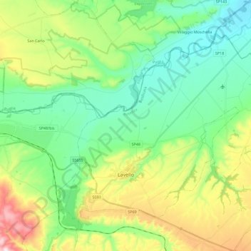
Name: Lavello topographic map, elevation, terrain.

Location: Lavello, Potenza, Basilicata, 85024, Italy (41.01605 15.73384 41.13954 15.96007)

Average elevation: 236 m

Minimum elevation: 89 m

Maximum elevation: 569 m

Gear up for your next adventure:

🦯Trekking Poles - Reduced impact on joints for steep topographic climbs
🧣Merino Neck Gaiter - Protects against wind, sun, and cold at high altitudes
💡Compact LED Flashlight - Powerful and portable flashlight for outdoor use
💧Collapsible Water Bottle - Space-saving water bottle for outdoor activities
🧭GPS Handheld Device - Reliable GPS navigation for outdoor adventures

As an Amazon Associate, this site earns from qualifying purchases at no extra cost to you.